
Long White Gypsy uses affiliate links and is a member of the Amazon Services LLC Associates Program. If you make a purchase using one of these links, I may receive a small commission at no extra cost to you. See my Privacy Policy for more information.
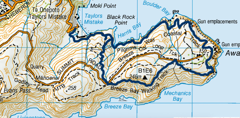
Click the map image to go to the detailed NZ Topo Maps page.
The Godley Head Walk is one of the most scenic day hikes in Christchurch, meandering its way along the Awaroa / Godley Head peninsula at the north eastern tip of Christchurch’s Port Hills and Lyttelton Harbour.
In the 7 years I’ve lived in Christchurch, this is one of my favourite & most picturesque walks. I first hiked the Godley Head Loop Track back in 2018 and I keep returning to it again and again, especially because it’s such an easy drive from the city centre. There’s still plenty to explore & love about it!
There’s heaps to keep the whole family busy on this loop walk, including your furry friends (who are welcome on-leash and under control). Join the locals for a picnic on this track in the warmer months, or take advantage of the cooler temperatures and crystal clear views during winter.
Hooked yet? Great!
Keep scrolling to find out all there is to know about the Godley Head Walk.
prefer to watch?
Watch the video of my Godley Head hike by clicking play below.
Godley Head Walk Guide – What To Expect.
Track Info
Dogs permitted on leash
Mountain bikes not permitted
Track Notes for the Godley Head Walk
| LOCATION | Taylors Mistake, Christchurch |
| WHEN TO GO | All year round. |
| TRACK GRADE | Easy to Moderate |
| TOILETS | At Taylors Mistake car park and Godley Head carpark. |
| WATER | At Taylors Mistake toilets and Godley Head toilets. No other potable water on this track. |
| PHONE RECEPTION | Very good in most places, but none at Taylors Mistake (so don’t plan to organise transport from here). |
| TRANSPORT | Self-drive to the Taylors Mistake car park is the best option. The closest public transport will get you to Nayland St in Sumner, but you’ll have to walk almost 4 km (50mins) up and over the hill to get to the start of the track. |
| HAZARDS | Steep cliffs with drop-offs along some parts of the track, narrow tracks, falling rocks, grazing livestock (sheep), mountain bikes and dogs may be present on or near some parts of the track |
| SPECIAL GEAR | Take plenty of sun protection (hat, sunglasses, sunscreen, long layers) with you as there’s very little shelter or shade on this track. |
The Godley Head Walk starts and ends at the car park at Taylors Mistake, approximately 30 mins drive from the centre of Christchurch city. It meanders around the large mass of Awaroa / Godley Head on its way past historic cave dwellings and seaside baches, gun emplacements and WWII military batteries to some of the best coastal views in Christchurch.
The Godley Head Loop track can be walked in either direction. The clockwise direction is more popular but gradually climbs the whole way, whereas the anticlockwise direction is more generally downhill but involves two steeper climbs.
Following is a description of the Godley Head Walk loop track section by section in a clockwise direction.
The Route.
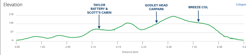
The Godley Head track is a 9.3 km / 5.7 mi loop track which is best walked in a clockwise direction. The total ascent over the distance is approximately 335 m / 1099 ft. It can be broken down into the following sections:
Taylor’s Mistake to Taylor Battery / Scott’s Cabin – 3.5 km / 2.2 mi – 1hr-1hr30m
Taylor Battery to Godley Head Carpark – 1 km / 1.4 mi – 15min
Godley Head Carpark to Breeze Col – 3 km / 1.8 mi – 45 min
Breeze Col to Taylor’s Mistake – 2 km / 1.2 mi – 30 min
Taylor’s Mistake to Taylor Battery / Scott’s Cabin
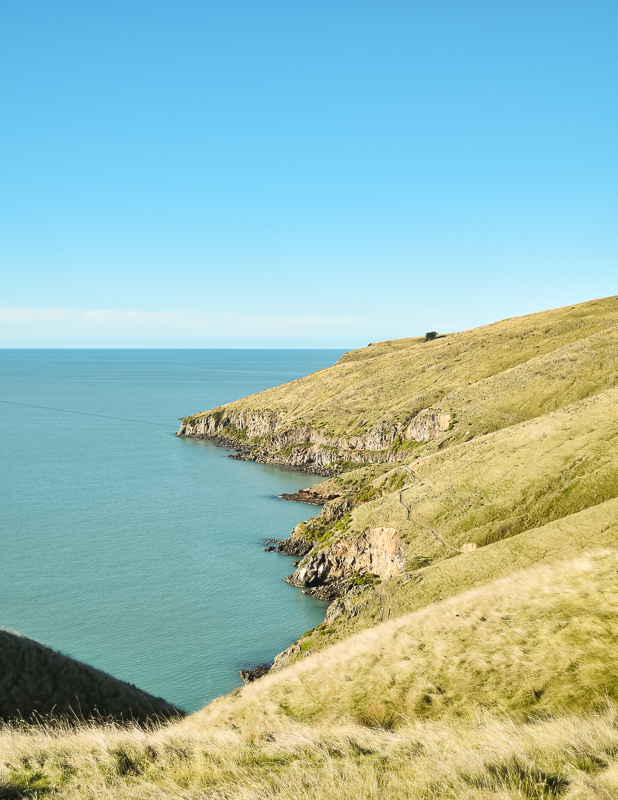
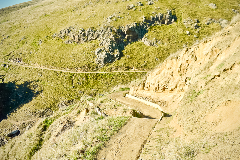
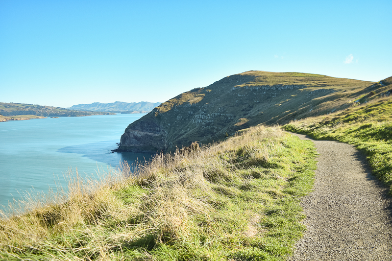
The Godley Head Walk begins with a picturesque coastal pathway (reminiscent of something you’d see on the South West English coast) which first passes by the famous Rotten Row baches before meandering along the edge of Taylors Mistake bay on its way to the tip of the headland. It climbs gradually along this portion, and the track is narrow in places with some steep drop offs.
You may be lucky enough to spot nesting white-flippered penguins (only found in Canterbury) on this part of the track between August and January, Hector’s Dolphins (Dec – Feb), fur seals and even whales (orca, blue & southern right).
You might also be able to see the remnants of historic cave dwellings along the shoreline here. These cave dwellings were first occupied in the 1880s. Young men came here during the summer months for fishing & leisure and found natural shelter in the caves. Soon they were erecting frontages and bringing in furniture to make them into proper ‘houses’. They were later popular with returned war veterans.
Many of them have now been demolished (due to Council sanitation rules) but the caves they were built into as well as some concrete and steel structures still remain.
There are spectacular views along the section across to Scarborough Point and (as you get towards the end of the peninsula) out to Pegasus Bay and the Kaikoura coastline.
An example of the clay-cut track along the exposed coastline. 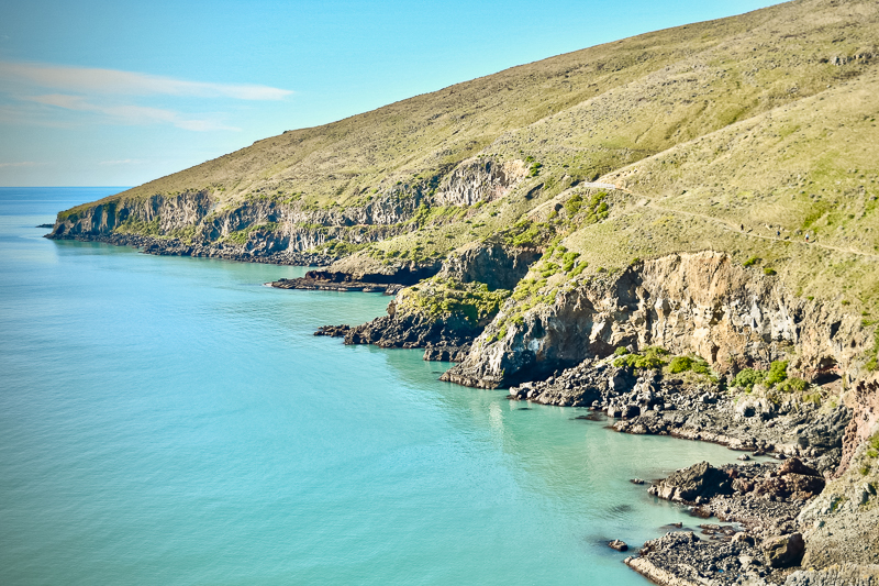
A particularly scenic coastal vista on the Godley Head Walkway.
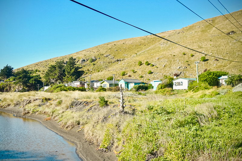
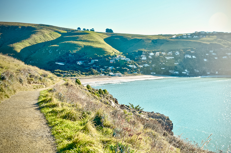
At the end of the headland, walkers can make their way down to more iconic baches at Boulder Bay. The earliest of these was built at the turn of the century, with the rest mostly built in the 1930s. They tell a story of a bygone era and are passed down from generation to generation.
At Boulder Bay the track begins a slightly steeper climb to the gun emplacements at Taylor Battery.
Scott’s Cabin
A little further on from Taylor Battery now sits Scott’s Cabin – a structure which is very close to my heart!
I’ve long-been fascinated by Antarctica and this little cabin has a long and storied history. Originally intended as a meteorological station for Robert Falcon Scott’s Antarctic expedition in 1911, It was constructed by a firm called Boulton & Paul in a town called Norwich in England – about 30 minutes from where I grew up!
The hut was wrapped and loaded onto Scott’s ship in 1911 bound for the Antarctic, but the expedition meteorologist wasn’t able to make the trip. So when they arrived, the hut was never used.
Of course, Scott and his entire party perished on the return journey and the hut was returned to Lyttelton in 1912 and eventually Clifton Hill where it sat and was used as accommodation by a number of historical figures until the 2011 earthquakes.
In 2013, having now been gifted by its owners to DOC, the hut was rescued from its red zone location and transported to Godley Head. It has been sitting there ever since.
Taylor Battery to Godley Head Carpark
From Taylor Battery either continue along the main path or I recommend taking the side-track to Scott’s Cabin. This little gem of history appealed instantly to my love of adventure travel and the Antarctic and is well worth a visit.
This prefabricated cabin was built in Norwich, England (about an hour from where I grew up!) for the 1910 – 1913 British Antarctic Expedition led by Captain Robert Falcon Scott. It’s purpose was originally as a meteorological research station, but the expedition meteorologist couldn’t make the trip, and so it remained wrapped & unused!
It was brought back to Lyttelton in 1913 and sited at Clifton Hill. It remained there until the 2010-11 Christchurch earthquakes when it was moved to its current site.
From Scott Cabin head back towards the main track which continues in a general upwards direction towards the Godley Head WWII Coastal Defence Battery.
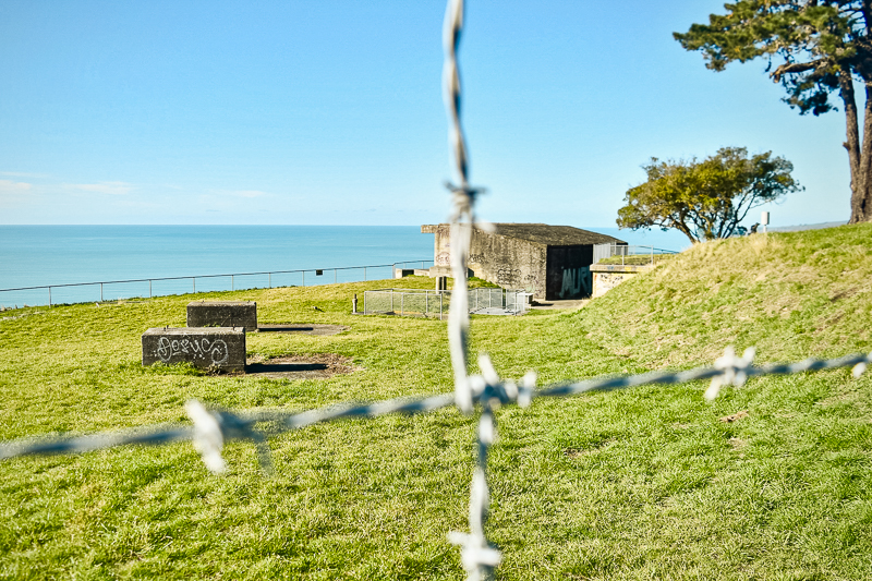
Here, there are expansive views out across the peninsula to the north and south as well as a maze of old military buildings, gun emplacements and tunnels to explore. The Godley Head tunnel walk is well-lit and contains informational panels outlining the history of these structures.
⚠️ IMPORTANT NOTE – GODLEY HEAD ASBESTOS
Over a number of years asbestos at Godley Head gun emplacements, lighthouse and campsite has been remediated. You can now visit all these places without restriction. However, for your safety, stick to all signage and do not enter restricted areas.
Some of the buildings have been decorated in interpretive graffiti to discourage vandalism. This graffiti is historically accurate, and some of it showcases the role of the Women’s Auxiliary Army Corp at this location during WWII.

From the Godley Head Gun Battery follow the track in a southerly direction past the eastern reaches of the Godley Head campsite. Pass through a gate here before beginning a short but steep descent down to another gun emplacement, precariously perched on the edge of the cliff.
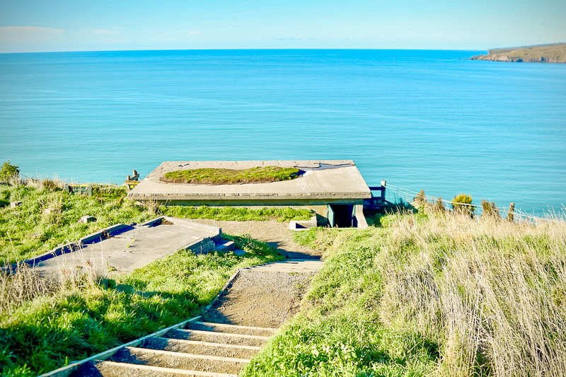
See the full splendour of the Lyttelton Harbour outlet as it opens up to the Pacific Ocean from this unique vantage point before continuing on around the headland past yet more military buildings.
A few minutes further up the track you’ll arrive at the Godley Head carpark, where there is a rudimentary set of toilets. Turn right here for the Godley Head campsite (temporarily closed due to asbestos).
Godley Head Carpark to Breeze Col
Things get a little confusing at the Godley Head carpark, so either keep left on the pathway which runs along the bottom of the car park, or head out onto Godley Head Road (accessed from a junction with Summit Road) and turn left onto the walkway which is 50 metres / 55 yards past the cattle stop.
From here the track now climbs to the highest point at 215 metres / 705 feet. You’ll get some excellent views from this vantage point as the track snakes its way around the hill, opening up views towards Diamond Harbour across the water.
You’re also likely to encounter grazing sheep through this next section, so be on the lookout for these, leave gates as you find them and make sure not to come between mothers and their lambs.
The next section of the track presents an ongoing risk of fallings rocks & debris due to unstable rocky bluffs and cliffs following the Christchurch earthquakes. Be aware of your surroundings through this section, watch out for signs of moving terrain and move quickly without stopping to linger.
The track is very narrow through here, with steep drop-offs down to the water below, so watch your footing and keep an eye on young children and dogs.
Once you’re past the rocky section the track starts to flatten out again and soon you’ll reach Godley Head Road and Breeze Col.
Breeze Col to Taylors Mistake
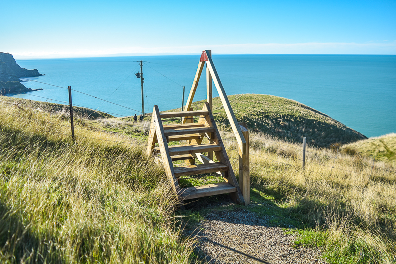
From Breeze Col, cross the road and look for signs for the Black Rock Track and Harris Bay. This track heads steadily downwards for approximately 20 minutes until you re-join the Pilgrims Way Coastal Track.
This is a separate walking path to the Anaconda mountain biking path which also follows the same general direction back to Taylors Mistake. Make sure you don’t accidentally end up on the mountain bike track.
From here, continue back along the way you came to Taylors Mistake carpark and the end of your hike.
Things to Know.
Steep Cliffs
Sections of this track are steep and narrow, with a risk of falling rocks. Keep your wits about you, watch where you’re going, be considerate and share the track with other users, and supervise young children and animals at all times. Check out more of my hiking safety tips for more ideas on how to handle hazards on trail.
Limited Shelter
There’s almost no shelter from the elements on this track, whether that be sun or wind/rain. On a hot summer’s day, with little breeze, you will find that this track gets very hot and you may drink more water than normal. Make sure you have the proper sun protection (sun hat, long layers or sunscreen, sunglasses) and you drink plenty of water. During winter or on a windy day, the coastal winds and cold air may tire you out a lot quicker. Always make sure to carry a waterproof layer and a set of warm thermal layers, gloves and beanie just in case.
Limited Water
Apart from at the toilets at Taylors Mistake car park and Godley Head carpark, there are no places to fill up water bottles on this track, so you should ensure you’re carrying as much as you need from home. I recommend a minimum of 2L of water per person for this track, but more if it’s a very hot day.
No Cellphone Service
Being located at the bottom of steep cliffs that block the signal, there is no cellphone reception at Taylor’s Mistake car park. It is possible to receive calls and text messages at other points on the track, but if you need to arrange transport to/from Taylor’s Mistake when you arrive or leave you’ll need to do so beforehand.
Popular Track
Being so close to Christchurch CBD this is a very popular track, especially on weekends and public holidays when the locals come out to enjoy the track with their families and four-legged friends. It can get quite busy and cramped in some sections, so be prepared to be patient and to share the track with others.
How To Get There.
Use the map above to get directions to the trailhead via your phone’s map app.
The natural starting point for the Godley Head / Awaroa Walkway is at the Taylors Mistake car park, a 30 min drive from Christchurch CBD. Head south east out of the city centre for 20 minutes on the Sumner Road, then follow the road to Taylor’s Mistake up and over Sumner Head for approximately 10 minutes until you reach the beach.
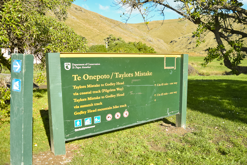
From the car park, find the sign for the Te Onepoto / Taylors Mistake track via the Pilgrim’s Way track, then follow the small pathway towards the far end of the beach, where you’ll pick up a stone staircase leading to the start of the track.
You can also access the track from the Godley Head Carpark on top of the hill (get there via Godley Head Road) but in my opinion it’s far easier to start/end at Taylors Mistake.
Track Grade & Fitness.
This loop walk track is classified an Easy Walking Track by DOC. The path is well formed and maintained, and either a gravel, clay or stone surface exists for much of its length. It is mildly undulating with one or two big hills to climb.
A moderate level of fitness is required. The first part of the track climbs gradually to the gun emplacements. From Godley Head Carpark there is a relatively short but steep climb to the high point at 215m / 705ft before heading back down to Breeze Col.
If you’d prefer an easier walk which is still very scenic or if you’re just short on time, you can do the Taylors Mistake to Boulder Bay walk which is only a 5 kilometre return trip via the same track, and avoids most of the hills.
Facilities.
There are toilets at both the Taylors Mistake and Godley Head carparks depending on where you choose to start. The Godley Head carpark is approximately half way along the track so this makes a convenient rest stop.
There are very few other facilities on the track, but the track intersects Godley Head Road on the second half of the track should you have an emergency.
Food & Water.
This is an almost three hour walk in very exposed coastal terrain. There’s almost no shelter on the track, meaning that on a hot day there’s a risk of sunburn and dehydration.
There’s nowhere to fill up water bottles along the route (except perhaps at the Godley Head carpark toilets if you’re desperate) so carry all the water you’ll need from home. I recommend a minimum of 2L per person for this hike, more if it’s a very hot day.
You’ll need enough food or a packed lunch to sustain you for 3 hours walking moderately on the track. This should include high energy slow release foods such as nuts and raisins.
Godley Head Walk – What To Pack
My New Zealand day hiking gear list contains a full breakdown of all the hiking gear you’ll need for this walk.
Specifically for this track, I recommend you pack plenty of sun protection (hat, sunglasses, sunscreen, extra water) on hot days as there’s very little shelter or shade on this route. Similarly for windy or cold days, where you’ll thank me for taking an extra warm layer and your water/windproof outer layer.
FAQs: Godley Head Walk.
How long is the Godley Head walk?
The Godley Head Walk is 9.3 kilometres / 5.8 miles long and takes between 2.5 and 3 hours to complete. The track starts at Taylors Mistake beach and circumnavigates Godley Head on Christchurch’s Port Hills.
How long is Boulder Bay walk?
From Taylors Mistake carpark it’s 2.5 kilometres / 1.6 miles to Boulder Bay. It will take an average hiker between 30 minutes and an hour to reach Boulder Bay from Taylors Mistake.
Are dogs allowed at Godley Head?
Yes, dogs are allowed at Godley Head and on the Godley Head Walk, but they must be on leash and under control at all times, as this track is narrow in places and can get very busy.
Is the Godley Head Walk open?
Yes, the Godley Head Walk is open, but unsafe levels of asbestos have been discovered at the gun emplacements, Godley campsite and the old lighthouse cottage. These structures have been closed off as a result and there are detours in place around them, but you can still do the Godley Head Loop walk.
Final thoughts: Godley Head Walk.
The Godley Head Walk is a stunningly beautiful yet easily achievable day hike just a short 30 minute drive from Christchurch CBD. Although it involves short climbs in some sections, it’s a great opportunity to build fitness whilst immersing yourself in the great views and the possibility of spotting native wildlife.
The track is suitable for families and is also very popular with dog walkers, so be prepared to share the track with others especially during busy periods like weekends and public holidays.
I’m sure that by following the advice in this Godley Head Walk Guide, you’ll have a safe and enjoyable trip, but if you’d like to know anything else about this track feel free to contact me here.