Long White Gypsy uses affiliate links and is a member of the Amazon Services LLC Associates Program. If you make a purchase using one of these links, I may receive a small commission at no extra cost to you. See my Privacy Policy for more information.
The best hikes are the impromptu ones … where you get that itching feeling in your feet and just know you have to head out on trail. That’s the feeling that overcame me just before I decided to hike the Kinloch to Kawakawa Bay Track (or “K2K”) in the Taupō region of New Zealand’s Central North Island.
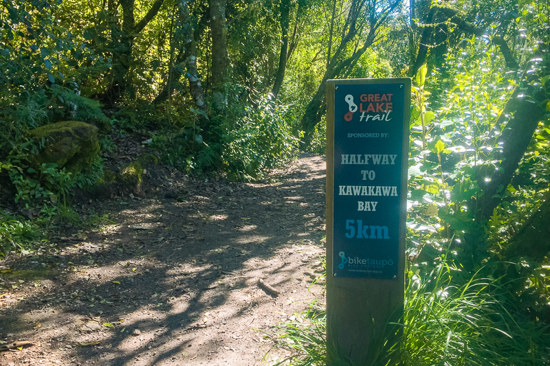
An 18km return trip from the township of Kinloch to the magnificent Kawakawa Bay, the Kinloch to Kawakawa Bay Track forms part of the Great Lake Trail, a 72km / 45mi mountain bike trail which skirts the shores of Lake Taupō, New Zealand.
It had been two very long months in the unrelenting heat of the Texan summer before I took my first steps on the K2K. Spending most of my days inside air conditioned environments, I hadn’t seen or touched a tree in weeks. A brief sojourn to the Lone Star Trail resulted in hiking less than a mile (return) in the 77°F / 25°C humidity. At least it was under cover of the canopy above!
And so, upon returning to New Zealand, I had one thing on my mind … getting back out into the great New Zealand outdoors! It simply couldn’t come fast enough. The combination of cooler weather, together with some of the most beautiful blue spring skies (and temperatures) were calling to me … and I needed to go.
And so, I shoved everything I thought I would need into my pack, and headed out to Kinloch to have a crack at what is known around these parts as the “K2K” – the Kinloch to Kawakaway Bay track.
Track Info
Dogs permitted (under control)
Mountain bikes permitted (Grade 3)
Track Notes for the K2K (Kinloch to Kawakawa Bay Track)
| LOCATION | Taupō, Central North Island |
| TRACK GRADE | Easy |
| TOILETS | Public toilets at Kinloch carpark opposite The Store & long drop at Kawakawa Bay. |
| WATER | No running water along the track, but there is a tap at Kawakawa Bay. |
| PHONE RECEPTION | Intermittent |
| TRANSPORT | Self driving is the best way to get to the start of this track in Kinloch. |
| HAZARDS | Shared use track with mountain bikers, keep left and stay alert at all times. |
| SPECIAL GEAR | Walking shoes or boots with good grip as this track can get very muddy after lots of rain. Trekking poles will be an advantage after heavy rain. |
prefer to watch?
Watch my video from the K2K Kinloch to Kawakawa Bay Track by clicking play below.
Things to Know.
Beware of Bikes!
Created primarily as a mountain bike trail, the Kinloch to Kawakawa Bay Track is well-formed but winding. Due to the growing fame of the Great Lake Trail, as a tramper be prepared to encounter plenty of mountain bikes on this track. Be especially careful as you round corners, and in spots where there is less visibility. Whereas most mountain bikers are generally on guard for other users of the trail, sometimes the odd one seems to get caught up in the moment!
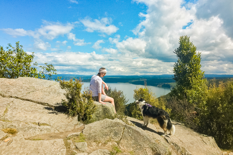
A Dog Friendly Track
Aside from the risk of mountain bikers, I found the Kinloch to Kawakawa Bay Track a particularly good option for a longer dog-friendly hike in this region.
I deliberated for a little while over whether to take our 15 month old border collie Tilly with me on this little jaunt: for one thing, it was a (relatively) hot spring day, and I wasn’t sure if her little legs could stand up to an 18 kilometre / 5 hour round trip. Up until this point, she’d be on some longer hikes with me before, but this one was double our previous record.
But she took it in her stride like an absolute champion. It turns out that she loves being in the bush too!
How to get there
Use the map above to get directions via your phone’s map app.
The Kinloch to Kawakawa Bay Track is easily accessed from the small township of Kinloch, approximately 10 minutes’ drive from Taupō. If entering Taupō from the north, take the Poihipi Road turning on your right just after the scenic lookout (there is a giant road bike sculpture on the side of the road at the junction). Continue along this road for a little way, past Tuhingamata and Mapara Rds until you reach the left hand turning of Whangamata Rd. The road is clearly signposted, including signs for the Great Lake Trail.
You’ll soon come to Kinloch Rd, another left-hand turning. Travel along this road all the way into town and follow the signs for the boat ramp (Mata Place). Opposite the boat harbour (just next to the Tipsy Trout cafe/restaurant) is a reserve area with some carparking and an informational graphic under a small shelter. Park your car here for an easy return to the trail.
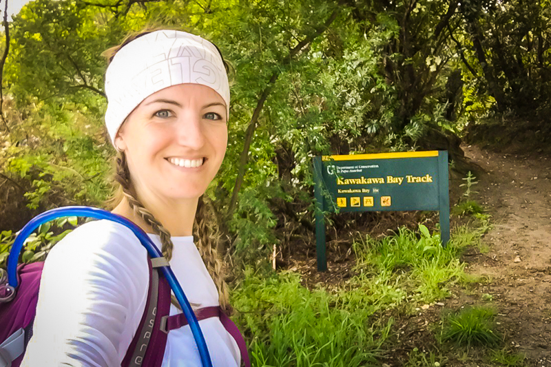
Once your car is secure, head down to the lakefront, and veer right. You’ll walk along a small pathway for a kilometre or so, and over a small bridge across the Whangamata stream as it enters Whangamata Bay. A little way further along the track, you’ll come across the Kawakawa Bay Track trailhead.
Track Grade & Fitness.
The Kinloch to Kawakawa Bay Track is classified as an Easy walking track by the Department of Conservation. Trampers should be aware, however, that it’s undulating in nature and does involve some climbing.
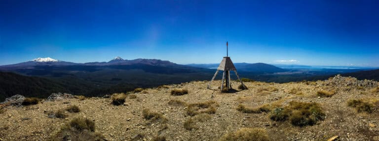
The highest point on the track is the Codger’s Rock lookout (492m / 1,614ft) which you reach after approximately 2 hours of hiking. It’s a steady and constant climb to reach this point.
The necessity of climbing up and over Te Kauwae point makes the Kinloch to Kawakawa Bay Track a steady uphill climb in both directions, however at no point did I find myself puffing and panting. Trampers with average fitness should complete this trail within a 4-5hr timeframe (depending on breaks).
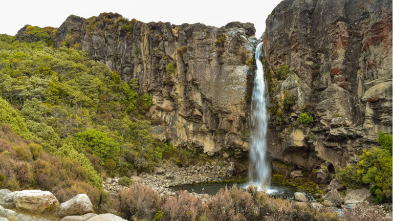
The majority of the track (except for a short section as you approach Kawakawa Bay) is under cover of the surrounding bush and trees. The bush is dominated by rewarewa (“ray-wah-ray-wah”) trees, characterised by their spiky red blooms which flower late-September to early October (I looked it up, so I hope this is right!). Keen botanists should also be able to spot giant matai (“mah-tie”) trees in amongst the ground cover … my nature skills being severely lacking, I was unfortunately completely oblivious to this.
Facilities.
Although this is a lengthy 4 to 5 hour return trek through the wilderness, there are very few facilities along the way. This is largely due to the fact that the Kinloch to Kawakawa Bay Track has primarily been developed for mountain bikers who travel much faster.
Aside from the public toilet facilities at the Kinloch marina and store, there are no other toilets on the track until you reach the campsite at Kawakawa Bay.
Tent pitches at the campsite are level, but secluded in the dark and damp of the dense bush cover. I have heard rumours that this site can become infested with rats over summer, but have not experienced that by myself.
There is a long drop toilet at the campsite, and a (new) open-sided shelter with a roof and some bench seating. It would be possible to sleep under this shelter if you didn’t have a tent, but it could get quite cold and windy depending on the weather.
I believe there is also a tap at the shelter and campsite to fill up your water bottles, but water should be treated before drinking.
Food & Water
On a hot day, you’ll easily get through 2L of water due to the undulating nature of the K2K terrain. Once you pass the trailhead, there are no free-flowing streams, so make sure to take enough with you for the duration.
You’re also well advised to pack plenty of energy-intensive food for your lunch. Whereas the track is not particularly steep, it is a steady climb for most of the way, and so hikers with lower than average fitness may require more rest breaks.
Seasonal Variations
The Kinloch to Kawakawa Bay Track is relatively sheltered, with almost its entire length traversing through dense bush cover on the shores of Lake Taupō.
Although this means it’s very cool and protected from the sun during summer, the K2K can be damp and cold during the spring & autumn, and of course during the winter.
Lake Taupō often experiences biting southerly winds and wet westerlies. The bush provides some shelter from this, but the track can still experience strong wind gusts in less dense sections. This can lead to hypothermia in the right conditions.
The track is mainly formed of a rough path cut through dirt. Because it is used frequently by mountain bikers it can be very muddy and boggy in places but especially so after heavy rain. Boggy sections can be much more difficult to walk, so be prepared for it to take some extra time to complete the track in or after bad weather.
More Tracks In This Region

The Route.

From the K2K Trailhead at the end of the Kinloch lakehead path, the Kinloch to Kawakawa Bay Track steadily climbs towards the Codger’s Rock lookout – the highest point on the trail. Expect this portion of the trail to be long and arduous. The closeness of the bush cover coupled with infrequent opportunities to see very far into the distance can make the track feel neverending and claustrophobic.
After what feels like an age of walking, you’ll come across a trail marker signifying the half way point to Kawakawa Bay. This is a great point to stop and rest for 10 minutes or so to have a quick snack and a drink.
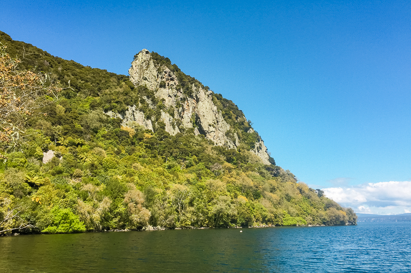
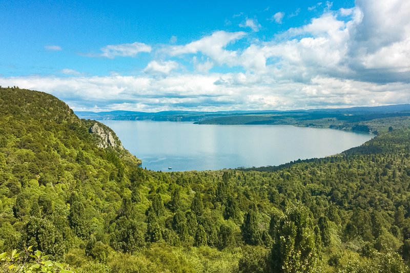
Approximately 2 hours into your outgoing march, you’ll notice the climb becomes marginally steeper. This is only for a short while until you eventually round a corner and see the view from Codger’s Rock lookout. From here, Kawakawa Bay stretches out in a magnificent horseshoe beneath you. The bay is encrusted with native bush, and just in front of you to the east is Te Kauwae peak (537m).
Codger’s Rock is another great place to stop and take a quick break but rest assured … from here it is only another 30 minutes to the bay. A short and easy grade downhill descent follows, most of which remains under cover of the surrounding bush. You walk through beautifully shaded ponga groves and also at one point through a brief uncovered section. In the hotter summer months this can be brutal after the luxury of shade for the rest of the track.
It’s not long after this that you’ll take the right hand fork in the track towards the Kawakawa Bay picnic area (continue straight onwards for the toilet). There is a small area set aside here for eating lunch, or you can choose to perch on the gravel shoreline as you soak your tired feet in the cool waters of Kawakawa Bay.
The cliffs of Kawakawa Bay rise threateningly almost immediately in front of you. I have since discovered that this location is particularly popular with rock climbers of the region, and in fact we hiked the remaining part of the trail with a group of climbers who were overnighting at the bay ready for a day of climbing to follow.
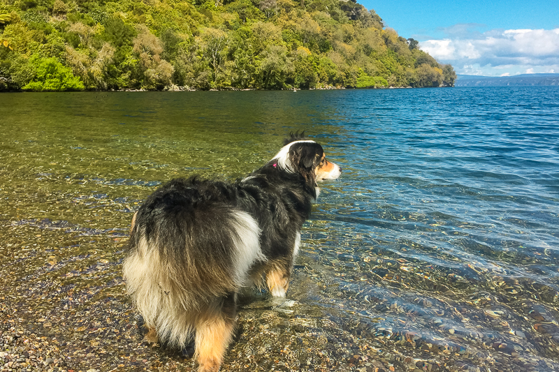
A Super Swimming Hole
Kawakawa Bay is a beautiful swimming spot, frequented only by the relatively few hikers, climbers and mountain bikers who take on the Kinloch to Kawakawa Bay Track. The waters are crystal clear and not too cold, and you’ll share their depths only with a select few ducks and small fish.
There is a shelter and campsite at Kawakawa Bay if you wish to turn your hike into an overnight adventure. However, be warned that the area can be frequented by rodents at nighttime. I overhead the guide who led the climbing group I followed educating his group members on how best to store their food and pitch their tents to avoid infestation by rats which must be particularly common in summer.
Return From Kawakawa Bay
Aside from turning around and hiking the K2K back to Kinloch, there are some alternative options for exiting the trail.
Whereas the Kinloch to Kawakawa Bay Track officially terminates at Kawakawa Bay, it is possible to continue on for another 10km all the way to Whangamata Road on the Orakau Track. The Department of Conservation website states that this should take around 3hours to complete. There is a steady elevation gain of 160m / 524ft over the 10km of trail to Whangamata Rd, with a couple of relatively steep sections – so be prepared to walk uphill for the majority of this section.
Alternatively, you can pre-book a water taxi with Bay2Bay which will return you to Kinloch.
Final thoughts.
If you’re looking for a slightly longer, animal-friendly walk in the Central North Island region, the Kinloch to Kawakawa Bay Track Track could be the right option for you.
By following the advice in this K2K Track Guide, you should have a safe and enjoyable trip, but if you’d like to know anything else about this track feel free to leave a comment below or contact me.
If you found this Kinloch to Kawakawa Bay Track guide helpful, please take a moment to help me spread the word to other trampers and hikers by sharing it on social media.