Long White Gypsy uses affiliate links and is a member of the Amazon Services LLC Associates Program. If you make a purchase using one of these links, I may receive a small commission at no extra cost to you. See my Privacy Policy for more information.

Click the map image to go to the detailed NZ Topo Maps page.
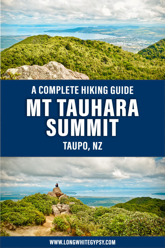
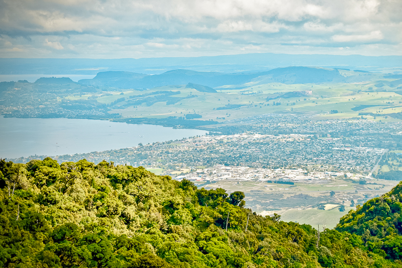
Mount Tauhara is located on the shores of beautiful Lake Taupō (the southern hemisphere’s largest freshwater lake) in the Central North Island region of New Zealand.
I lived in Taupō for almost 20 years, and the Mount Tauhara walk has to be one of my absolute favourite hikes. I’m ashamed to say that it took me almost ten years of living in Taupō before I eventually did it (!), but once I did, I couldn’t stop. It’s got the BEST views and is particularly spectacular at sunset or sunrise.
🔥 HOT TIP 🔥
If the Mt Tauhara hike is going to be your first mountain climb, check out my tips for how to tackle your first mountain hike.
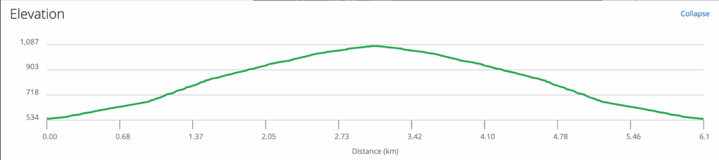
Although the distance is only 3km / 1.8mi, it’s 1 hour 30 minutes of pure climb… all the way. It definitely gets the heart pumping and the lungs working!
The Mt Tauhara height is 1,088 m / 3,569 ft above sea level, and on a clear day you can get panoramic views of the central north island, including Mounts Ruapehu, Tongariro and Ngāuruhoe in the Tongariro National Park to the south.
Things to Know.
Track Info
Location: Taupō, Central North Island, New Zealand.
Dogs not permitted
Mountain bikes not permitted
Track Notes for the Mount Tauhara Walk
| TRACK GRADE | Moderate to Hard |
| TOILETS | None on track or at trailhead. |
| WATER | No potable sources on track or at trailhead. Take at least 2L of water with you, or there is a stream approx. 15 minutes from the summit which must be filtered if you want to drink it. |
| PHONE RECEPTION | Excellent all the way. |
| TRANSPORT | Self-drive to the carpark at Mountain Road (details below). There is no public transport to this track. |
| HAZARDS | Very steep track, narrow in places, lots of roots and slippery mud (especially after rainfall), some sections (especially at summit) have steep drop-offs, first part of track goes through a working farm with grazing stock (sheep or cows), leave gates as you find them. |
| SPECIAL GEAR | Good sturdy hiking shoes or boots with plenty of grip, trekking poles may be helpful for some hikers, take a warm jacket for the summit which can be windy & cold. |
Working Farm
The first part of the Mount Tauhara walk traverses an operational farm (as is the case with many tracks in New Zealand). Cows may be present in the paddock on the lower slopes of the mountain at any time.
Approach herds with caution, and never come between mothers and their calves. If you’re unsure, turn around and come back another day.
When traversing farmland, always leave gates as you find them (find out more about that here).
It’s very important that you abide by the rules and conditions of use of private land. Farmers may revoke access to their land due to inappropriate behaviour from some trail users which ruins it for others.
Shooting Range
The Mount Tauhara track is very close to a local shooting range, so it’s common to hear gunfire whilst you’re on this track. Although the actual shooting range itself is far away from the track, sound reverberates around the natural topography of the mountain making it feel like it’s very close.
Track Markers
There are no trail markers along the majority of this track. This is because it traverses private land managed by the local iwi, rather than by the Department of Conservation.
That being said, the track is well formed and trampled (being very popular with local fitness enthusiasts) and is easy to follow.
Once you’ve passed the stream on the upper part of the track, you may notice some other small tracks off to the right at various intervals. It may be confusing at times which direction to take.
Follow the main brunt of the track, but don’t worry if you get off-trail. All tracks eventually lead to the summit of Mt Tauhara (it just might be a bit more of a climb to get there!).
Mountain Conditions Apply
Even though it looks unassuming from the relative safety of Taupō township, remember that this is still a mountain which juts over 1,000m above sea level, so you need to be aware of how to safely hike in these conditions.
Alpine conditions apply, namely that weather can change rapidly for the worse. Be prepared at all times by taking a small day pack with extra warm and water/windproof layers.
Sunrise or Sunset at the Summit
It’s common for people to hike the Mt Tauhara track either for sunrise or sunset to enjoy their breakfast or dinner on the mountain.
If you’re planning a sunrise or sunset trip I recommend you walk the track in the daylight first to get familiar with it.
On your nighttime attempt make sure to take a headlamp with you (and some spare batteries), and wrap up warm in thermal layers, a down jacket and long pants (even in the summer months) as it can get very cold on the mountain in the dark.
Finally, check the weather forecast to make sure it will be a clear night. The Milky Way stretches out above your head, and you’re bound to catch a few meteors as well!
prefer to watch?
Watch the full video of this trip on YouTube.
How to Get There.
Use the map above to navigate to the Mount Tauhara walk carpark.
The Mt Tauhara track can be accessed via Mountain Road, about 3.5km / 2mi down State Highway 5 after the intersection with State Highway 1. To find the Mount Tauhara car park, drive all the way to the end of Mountain Road until you reach the farm gates. There’s a paved area here for parking at the trailhead.
From the car park, follow the path through the gate to a stile over a fence then continue on through the farm paddock up a steep hill. The path is well worn and easy to follow, but is not well marked.
Mount Tauhara Hike Track Grade & Fitness.
This is a sometimes rough, steep and muddy track which winds its way up a spur on the southern side of Mount Tauhara to the summit.
The Mount Tauhara elevation gain is approximately 540m over 3km. This is a very steep grade which requires a good level of aerobic and physical fitness.
Cut into the mountainside, the track is comprised of dirt which turns to mud after heavy rain. The ground is covered in tree roots and there aren’t any steps, meaning that sometimes you have to clamber up a ‘step’ in the hillside on all fours grabbing onto roots. There is also a small section where you’ll have to climb up some rocks.
The middle reaches of the track (before you reach the stream) are very narrow in places with steep drop-offs to the side (although it is not open to the open air).
The popularity of the track means you may have to step off to one side to let others pass, so if you have vertigo or are scared of heights, you’ll need to prepare for this.
Walkers have had to be rescued from the Mount Tauhara hike on occasion, not just from the effects of cold and rain but also because of sprained or broken limbs. The track is steep and treacherous, be careful of your footing and take your time.
Mount Tauhara Track Facilities.
There are no facilities on or in the vicinity of the track. This includes toilets, so make sure you go before you leave home.
As already mentioned, there are no steps or other aides to climbing this track along the way.
Food & Water.
Although many locals do this track on a daily or weekly basis without carrying food, this is still a strenuous climb.
If it’s your first time you should take some sustenance with you. I suggest at least a couple of muesli bars or some nuts. The summit of Mt Tauhara is a good place for a spot of lunch if the weather is nice.
You’ll need to carry enough water with you to get up and back (I suggest at least 1.5L per person). Apart from the stream towards the top of the track (which should be filtered before drinking) there are no water sources on this track.
Mount Tauhara Track Seasonal Variations.
Mount Tauhara juts out of the landscape, 1,088m above sea level.
Although it’s located in the relatively settled climate of the central plateau region, it’s possible for the temperature to be a few degrees lower than the town centre at the summit, and in the winter the mountain sometimes sees snow.
Cloud can roll in very quickly, and it’s common for it to be very windy and chilly at the summit (even in summer).
Make sure you take appropriate layers with you regardless of the season, as conditions can be very different on the top of the mountain.
If it’s cold or windy when you arrive, spend only a few minutes before heading back down so you don’t risk hypothermia.
More Tracks In This Region

The Mount Tauhara Legend.
Like many other areas of geographic importance in New Zealand, Mt Tauhara and its surrounding land is looked after by the local tribe.
Mountains (or maunga as they are known in the Māori language) are very important in Māori legend. The following is the story of Mount Tauhara as told by Te Ara:
In the days when the earth was young there were four mountain warriors: Tongariro, Taranaki (Mt Egmont), Tauhara and Pūtauaki (Mt Edgecumbe). There was also the beautiful maiden, Mt Pīhanga. The warrior mountains fought for her affections, and after a long battle Tongariro emerged the winner. The defeated mountains decided that they should leave Tongariro’s domain. They were to travel as far as they could before dawn, when the rising sun would fix them to the spot. Pūtauaki headed east and by daybreak reached his present position at Kawerau. Tauhara travelled slowly, all the time looking back longingly at Pīhanga; he only reached the other end of the lake. Taranaki went west and still looks back, hoping for the day when he might return to avenge his defeat. Meanwhile, Pīhanga became the wife of Tongariro, and they had a child named Pukeronaki.
Te Ara – encyclopedia of new zealand
This is such a beautiful story, and it’s interesting to note that the Tauhara meaning is actually “alone” or “odd-one out”, which may derive from this legend.
The Mount Tauhara Track Route.
The Mount Tauhara walk is a 6 km / 3.7 mi out and back (return) track from Mountain Road carpark on the Napier-Taupō Highway (State Highway 5). The total ascent over the distance is approximately 533 m / 1,748 ft.
It can be broken down into the following sections:
Carpark to Water Tanks
Follow the well marked track across the farmland and head up over the first hill.
You’ll stroll along a plateau (with smaller climbs) for a little while and then head towards an electric fence (there might be cattle on the other side).
As you get to the fence, you’ll see a wooden stile up ahead. Just beyond the stile are two green water tanks, partially obscured by the bush.
You’ll already have ascended 150m by this point. This is the first landmark on Mt Tauhara, and a good place from which to enjoy the view.
Water Tanks to Seat
Almost immediately you’ll head into the covered bush of the mountain slopes.
The next section is hard grind, ascending steeply (although not quite as steep as the first slope on the farmland).
Watch your step! The trail is distinctive, but covered in exposed tree roots.
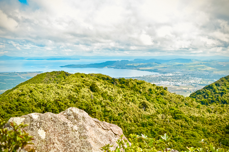
There’s opportunity to stop and admire Mt Tauhara’s amazing views of Taupō from small clearings along the way.
After about 15-20 minutes (and another 150m ascent) you’ll round a bend and come across a wooden seat.
This is the second landmark, and marks approximately the half way point of your hike to the top.
Seat to Stream
After the seat, the track continues in the same manner and gets a little more tricky with rocks to clamber around and larger tree roots to navigate.
It narrows in some places, and at one point you’ll find yourself precariously tiptoeing along the ridge edge whilst clinging to a rock which blocks the track.
For those with vertigo, don’t worry too much – my Mum has completed this many times (and she has vertigo!). The dense bush on Mt Tauhara screens much of the drop, and the track isn’t so narrow that your footing is compromised.
After about an hour of walking you’ll hear the sound of running water, and soon you’ll come across the stream to the left hand side of the track.
There is a space for you to climb down and dip your feet in if the desire takes you. You’re now about two thirds of the way up the mountain.
From the stream, keep following the main track. You’ll soon come across a long (25m) gorge off to the right of the track.
This is a cutting through an old lava flow, which you can navigate for a slightly more interesting route.
For those with less mobility, carry on down the main track to your left.
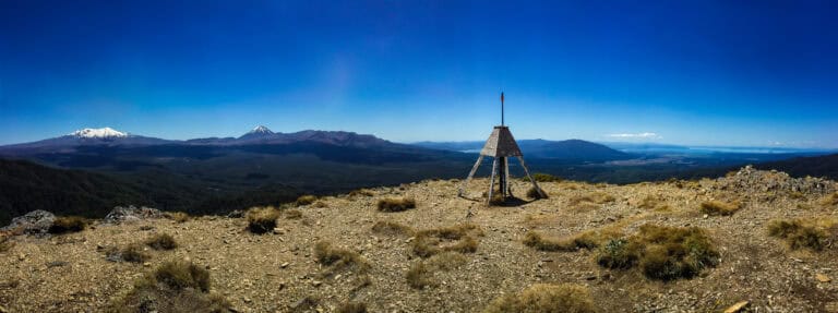
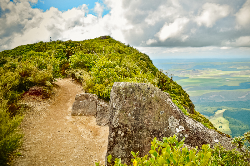
As you approach the summit, there are a number of different routes to take. Don’t despair – if you stay generally left you’ll end up at the trig point at the summit.
Forking right will bring you out part-way along the ridge track to the rocks.
Stream to Summit
Once you reach the summit, you’ll be treated to panoramic views of the central plateau region of New Zealand.
Lake Taupō spreads out majestically at your feet, and on a clear day you’ll see the peaks of the central North Island volcanoes – from left to right Ruapehu, Ngāuruhoe and Tongariro.
I’m told if you look northeast on a clear day you can see White Island (the volcanic island located 48km / 30mi off the Bay of Plenty coastline).
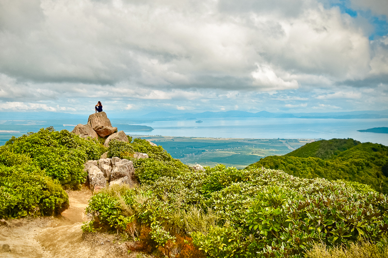
Head off towards the lake on the ridge track to see the views (and get a great selfie) from the rocks lookout.
The Mount Tauhara track is narrow, drops off in some places and you’ll find yourself brushing up against the bushes along the way.
But, it’s a great place to rest and relax – maybe even have a bit to eat.
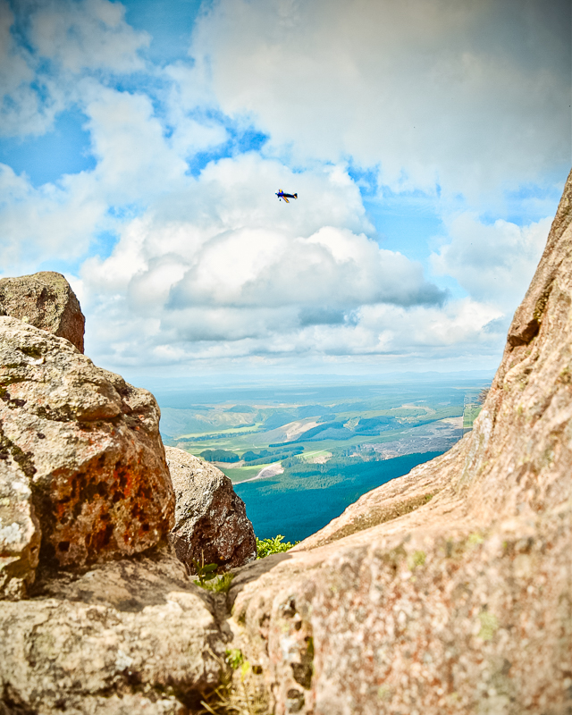
You might even be treated to a mini-airshow as you sit here and contemplate.
Mt Tauhara is often used as a focal point for light aircraft and gliders to circumnavigate on their scenic flights. The Mt Tauhara walk allows you an opportunity to see these aircraft from a unique vantage point.
The Descent.
The descent is all downhill, and so can be a little hard on the knees.
It’s tempting to get down as fast as possible, but make sure to take regular breaks to avoid “jelly-leg” syndrome, and also to keep your knee joints nice and healthy.
A litre or so of water for the track will see you right, and you’ll probably find it easier to carry it in a water reservoir in your pack.
If necessary, you can always refill at the stream if you need to top up (it is always recommended to filter your water).
You’ll need plenty of energy for both the ascent and descent, so make sure to pack enough snacks to get you through.
Mount Tauhara is a great picnic spot, so if you can take a slightly larger backpack (or split the load among more people) pack in some sandwiches and sausage rolls… it’ll be the most scenic picnic you’ve ever had!
Mount Tauhara: FAQs.
How long does it take to climb Mt Tauhara?
It takes around 1.5 hours to walk up Mt Tauhara. If you’re very fit, you may be a bit quicker than that. The track is very steep which will slow you down. It’s much quicker to get down and you can be back to the car park in just over an hour if you want. But there’s really no need to rush!
When did Mt Tauhara last erupt?
Mt Tauhara last erupted around 65,000 years ago, and it was these eruptions that formed the mountain itself. There’s been very little volcanic activity since then and it’s considered a dormant volcano.
Can you take dogs up Mount Tauhara?
No, unfortunately Mt Tauhara isn’t dog friendly. This is because it’s a private track which begins on a working farm. You’re likely to come across livestock (sheep or cows) on this track which means dogs aren’t allowed.
How high is Mount Tauhara?
How tall is Mount Tauhara? It’s 1,088 metres / 3,570 feet above seal level. Because the township of Taupō already sits around 500 metres / 1,640 feet above sea level, the total ascent on this track is only around 500 metres.
Final Thoughts: Mount Tauhara Walk.
The Mount Tauhara walk is a fantastic way to climb a mountain near Taupo and to get a sense of the geography of the Central Plateau created by the Taupō eruptions over the past 300,000 years.
Offering excellent views of Lake Taupō, the North Island volcanoes and much more, it’s a must-do walk when in the Central North Island.
By following the advice in this Mt Tauhara Track Guide, you should have a safe and enjoyable trip, but if you’d like to know anything else about this track feel free to contact me here or on Instagram.
If you found this guide helpful, please take a moment to help me spread the word to other trampers and hikers by sharing it on Pinterest (or on your social media).