
Long White Gypsy uses affiliate links and is a member of the Amazon Services LLC Associates Program. If you make a purchase using one of these links, I may receive a small commission at no extra cost to you. See my Privacy Policy for more information.
If you’re after a short but rewarding hike in the Central North Island, the Mt Urchin Track in Kaimanawa Forest Park ticks a lot of boxes.
With sweeping views over Tongariro National Park, mossy beech forest, and a clearly marked trail to the Urchin Trig, it’s a classic North Island hike that deserves way more attention than it currently gets.
This is a great option if you’re looking to get off the beaten track, but still get those epic volcanic views (without the pesky crowds of the Tongariro Alpine Crossing).
Here’s everything you need to know before tackling Mount Urchin.
Track Info
Dogs permitted with a DOC permit
Mountain bikes not permitted
Track Notes for the Mt Urchin Trig Track
| LOCATION | Kaimanawa Forest Park, Central North Island |
| TRACK GRADE | Advanced Tramping Track |
| TOILETS | None on track |
| WATER | None on track – bring at least 2L with you |
| PHONE RECEPTION | Mostly good |
| TRANSPORT | Private care to trailhead (no shuttles) |
| HAZARDS | Rough and uneven track, lack of water, steep grades, slippery and rocky surface at the top, trig is exposed to high wind & bad weather |
What to see on the Mt Urchin Track.
You’ll start off in beautiful, dense beech forest, climbing steadily through mossy undergrowth. The track climbs consistently but isn’t overly steep or technical.
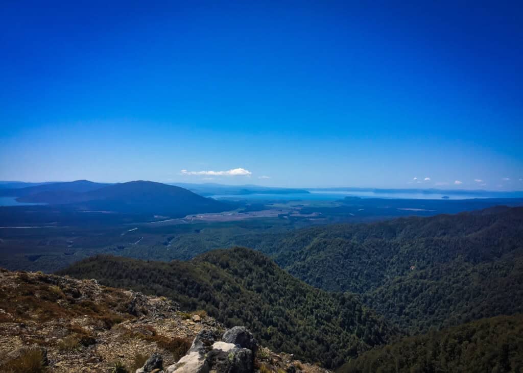
After about an hour, you’ll emerge above the bush line where the landscape opens up to a broad alpine ridgeline.
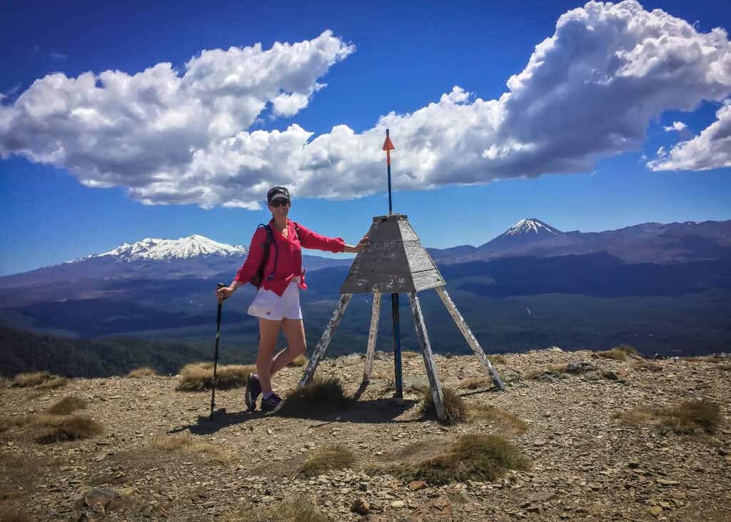
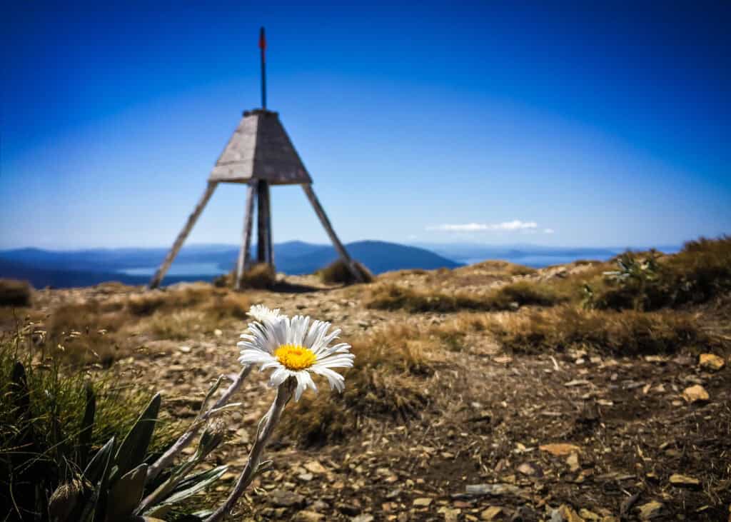
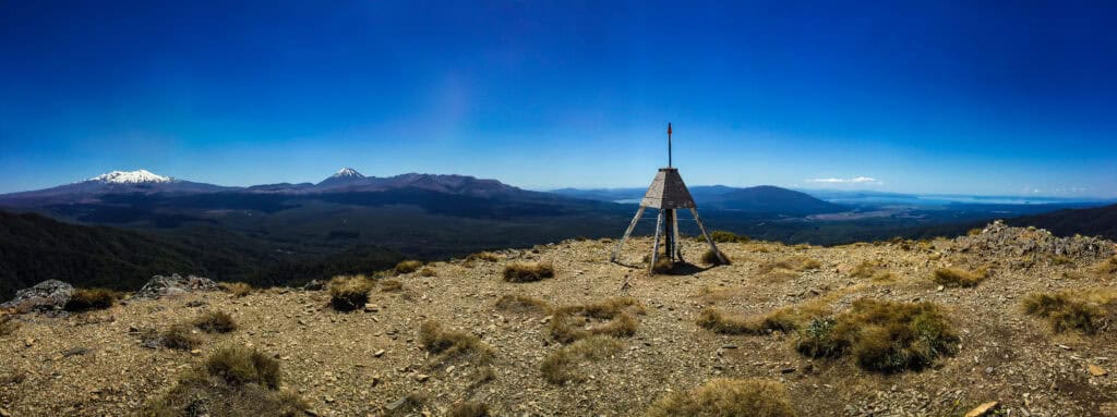
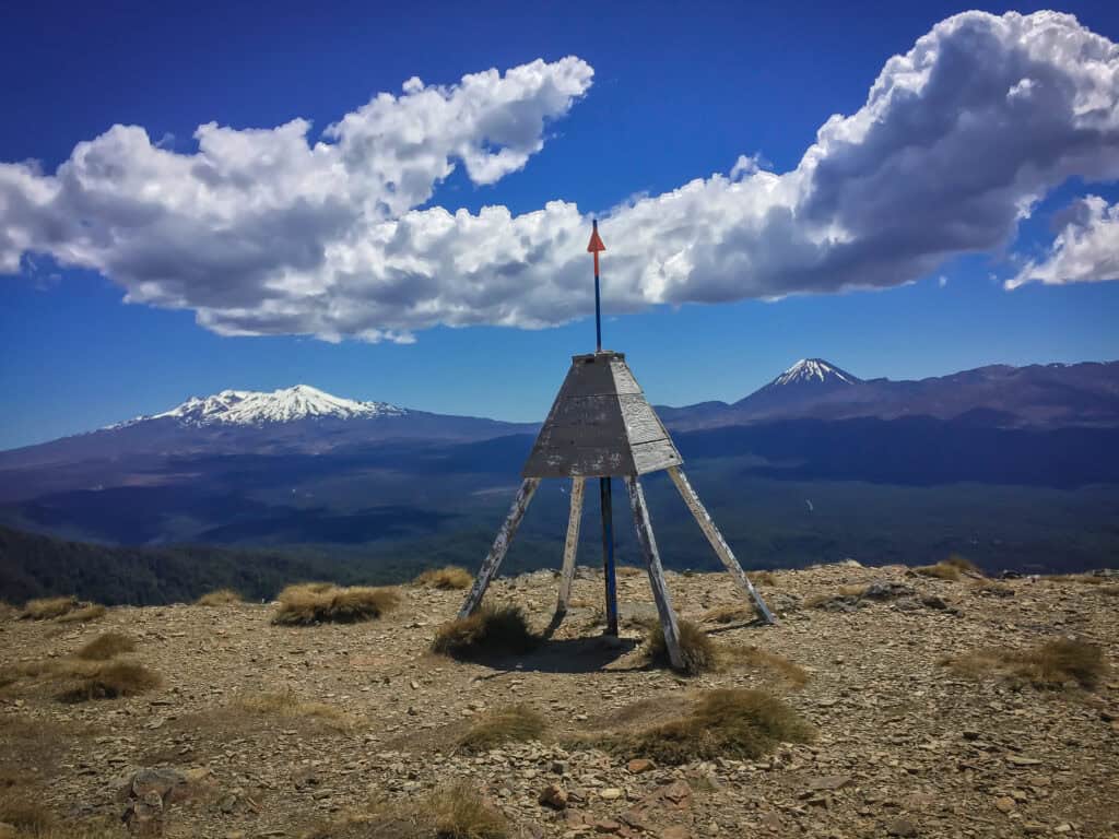
The views are spectacular. From the Urchin Trig (which sits at 1,391m/4,563ft above sea level) you’ll get sweeping views of Lake Taupō, and across to Mounts Tongariro, Ngauruhoe, and Ruapehu.
It’s worth a snack break here to take it all in.
In summer, alpine flowers bloom around the rocky trail.
In winter, expect snow and ice up top.
prefer to watch?
Watch my hike of this track on YouTube!
What to expect.
The track can be broken down into three distinct sections.
Section One
The first part of the track climbs reasonably steeply up nearly 400m of vertical ascent through gorgeously dense beech forest.
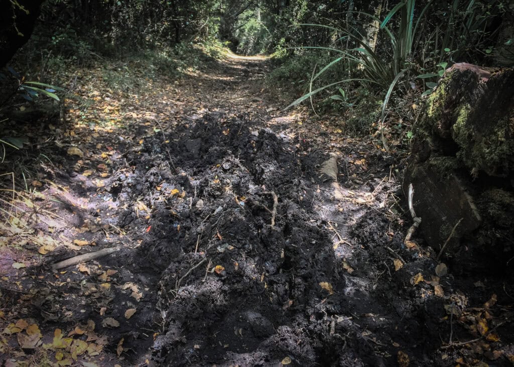
The track is well marked, but rough in places with tree roots and sections of muddy trail.
Section Two
The middle section of the track flattens out considerably, as you walk along the ridge, albeit still very sheltered by the native bush.
Although there are less roots, there is the potential for this part of the track to be very muddy and boggy still.
Section Three
The final and more technical hill climb, first through the forest and then out onto the slate-covered slopes of the upper reaches of Mt Urchin before finally arriving at the trig point.
This section is very loose and can be tricky for people not used to more technical terrain.
Getting there.
- From SH1 south of Turangi, look out for the left hand turn about 17km out of town (in the passing lane just past the SH46 turning) onto Kaimanawa Road.
- Drive 3.5 km down Kaimanawa Road to a junction and turn right onto Urchin Campsite Road (signposted Urchin Campsite).
- Continue past the Urchin Campsite and Pillars of Hercules to the Urchin carpark.
- The road ends at the Mt Urchin Track carpark, after climbing a short way. The road gets much rougher & steeper past the Urchin carpark, so a 4WD is recommended.
⚠️ IMPORTANT NOTE
The last section of road is rough and best suited to high-clearance or 4WD vehicles.
There are no public toilets at the trailhead, and no water sources along the track — so make sure you come prepared by going to the loo beforehand and bringing plenty of water with you!
How long does it take?
You can expect this reasonably short 6.6km / 4mi (return) out-and-back track to take a reasonably fit person roughly 3-4 hours to complete.
You’ll need to be fit enough to walk uphill for around 1.5 – 2 hours on a reasonably rough track to complete this hike.
This track is classified as an advanced tramping track, meaning that the track is rough and uneven, so don’t underestimate the terrain.
Also, weather in the Kaimanawa Forest Park can turn quickly, so you’ll need to check the forecast before you go.
Mt Urchin Campsite & Camping.
The Urchin Campsite is a designated DOC camping area near the start of the track, if you’re planning to stay nearby.
It’s very basic — expect a long-drop toilet, a bit of flat ground and not much else.
But on the plus side, it’s completely FREE to stay here.
From the campsite, you can also easily access the hugely popular nearby Tree Trunk Gorge Track and Pillars of Hercules Track, which are both reasonably easy walks.
If you’re a bit more adventurous, I know of a few people who have camped on the Kaimanawa tops along the Urchin to Umukarikari route trail. If you’re planning to do this:
- Be aware that the Kaimanawa tops are very exposed to inclement weather, although would be gorgeous on a calm day;
- Are also very exposed to hunters who hunt in and around this region year-round;
- Don’t have any water or toilet facilities, so you must follow Leave No Trace standards.
If you’re into a more adventurous route with a bit more comfort, you can continue along the Kaimanawa tops on the Urchin to Umukarikari Route to Waipakihi Hut for the night.
What to pack.
Because of the changeable Mt Urchin weather, make sure you come prepared.
Here’s a quick packing list for a day trip:
- 2L of water per person
- Windproof & waterproof jacket
- Warm layers (even in summer)
- Sturdy tramping boots or good trail shoes
- Sunscreen & hat (very exposed up top)
- Trekking poles (helpful for the loose slate on the Urchin tops)
- Plenty of snacks and a good lunch
- Personal locator beacon (PLB)
If you’re walking during winter, be especially cautious. The upper sections can get snow and ice — microspikes may be needed.
Track Conditions & Difficulty.
The Mt Urchin Trig track is classified by DOC as an advanced tramping track. That means:
- The track climbs steadily over uneven ground
- Expect tree roots, rocks, and some narrow sections near the top
- The route can be muddy and boggy, especially after lots of rain
- Visibility can be poor at the top in low cloud conditions, and strong winds can be dangerous at altitude
- Slippery and loose slate covers the top of the Urchin range
If you’re comfortable with a bit of a leg burn and want a half-day adventure with killer views, this is a great option! But don’t treat it like a walk in the park.
Tips Before You Go.
- Check the weather via MetService, NIWA (best forecast Waipakihi Hut) or the Windy app before heading off.
- Always leave your intentions with someone. This is an alpine area with potentially minimal cellphone reception.
- Take your rubbish home with you and if you need to toilet, go at least 50m away from the track.
- Bring more layers than you think you’ll need – even in summer!
Mount Urchin Photo Gallery.
(Insert a mix of trailhead, beech forest, alpine ridgeline, and Urchin Trig summit photos here)

Final thoughts.
The Mt Urchin Track is a short but punchy alpine hike that offers excellent value for effort.
It’s a great way to experience the rugged beauty of the Kaimanawa Forest Park, without committing to a multi-day tramp. Bring your camera, pack well, and don’t forget to look back at the views!
Whether you’re just passing through the North Island or live nearby, this is one track worth adding to your list.