Long White Gypsy uses affiliate links and is a member of the Amazon Services LLC Associates Program. If you make a purchase using one of these links, I may receive a small commission at no extra cost to you. See my Privacy Policy for more information.
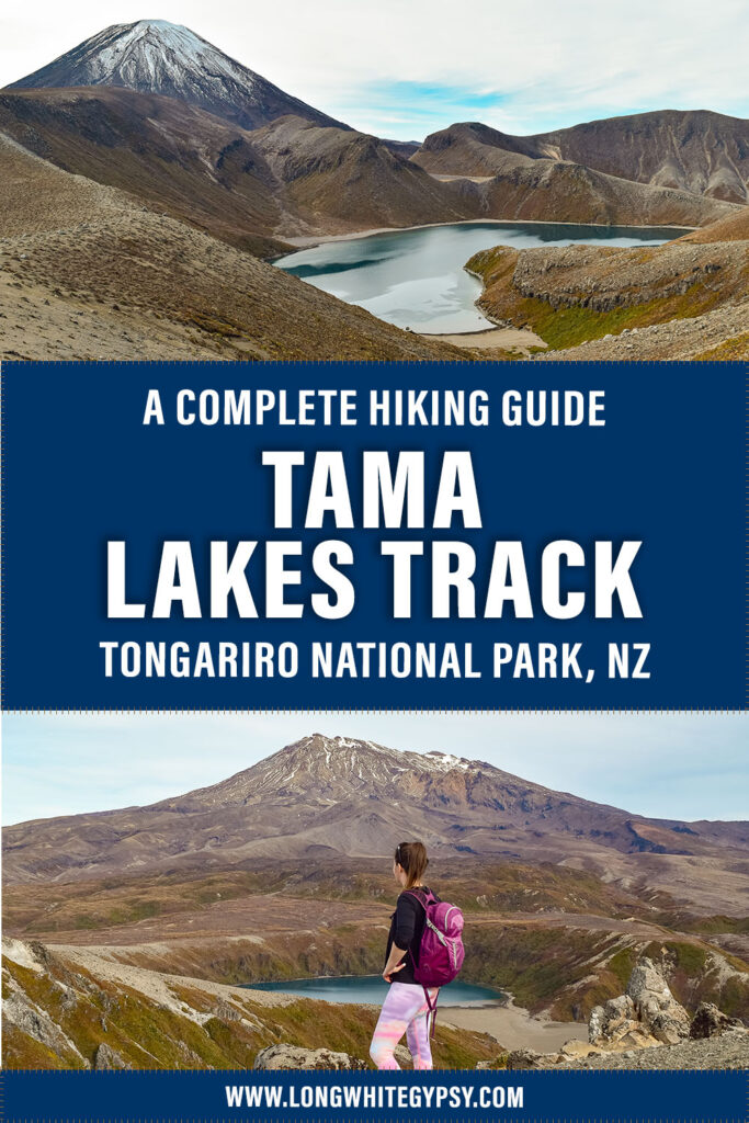
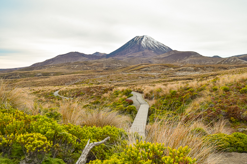
Little-known to many day hikers, the Tama Lakes Track showcases some of the best that Tongariro National Park has to offer. Undulating among ancient lava flows, through tussock and wild alpine terrain, this spectacular day hike culminates in panoramic views of the central north island’s largest alpine lakes (the Upper and Lower Tama Lakes) and abundant vistas of snow-capped mountain peaks.
Similar in length, the Tama Lakes Track has been touted as a fantastic (and slightly more adventurous) alternative to its more commercialised and often overcrowded neighbour, the Tongariro Alpine Crossing.
The Tama Lakes Track, in stark contrast, still retains it’s wild grandeur, and whilst the track was ‘busy’ on this adventure New Years Eve 2018, I still tramped large sections almost entirely without seeing another person.
Much of the track to the Tama Lakes forms part of the Tongariro Northern Circuit, one of only three of New Zealand’s Great Walks located on the North Island.
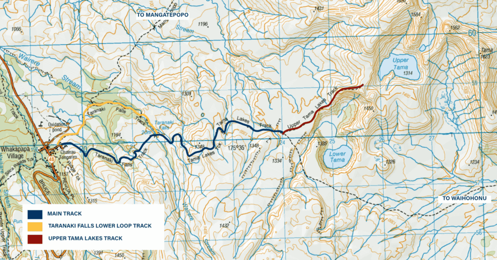
The Tama Lakes Track is a 17km / 10.5mi out-and-back trip, and can be broken down into the following sections (more detail in the Route section below):
- Upper Taranaki Falls Track – 2.8km / 1.7mi – 20-30 min
- Waihohonu Hut Track – 3.7km / 2.3 mi – 1hr
- Lower Tama Lake – 0.5 km / 0.3 mi – 15-20m
- Tama Saddle Track / Upper Tama Lake – 1.3-2km / 0.8-1.2mi – 20-30min
- Tamma Saddle / Upper Tama Lake to Whakapapa Village – 9km / 5.6mi – 2.5hr
Track Info
Dogs not permitted
Mountain bikes not permitted
Track Notes for the Tama Lakes Track
| LOCATION | Whakapapa Village, Tongariro National Park |
| TRACK GRADE | Advanced |
| TOILETS | Public toilets at Whakapapa Village DoC Visitor Centre. In summer (Oct to Apr), long drop toilets are also stationed at the Taranaki Falls lookout (approx. 1 hour into the walk) and at the Waihohonu Hut track junction (approx. 2 hours into the walk. In winter (May to Sep) toilets along the track are removed. |
| WATER | Water is available in the toilets at Whakapapa Village, and although the track crosses a few small streams it is not recommended to drink due to the volcanic environment. Carry at least 2-3L per person. |
| PHONE RECEPTION | Reasonably good all along the track. |
| TRANSPORT | Self driving to Whakapapa Village is your best option, but National Park Shuttles also operates a shuttle bus to Whakapapa Village from National Park Village. |
| HAZARDS | Unbridged streams, limited water, scree slopes & uneven terrain, very exposed terrain (no shelter from the sun or weather), strong wind gusts at Tama Saddle. |
| SPECIAL GEAR | In summer you’ll thank me for suggesting you bring an umbrella with you. Trekking poles are also an advantage on the climb to the Upper Tama Lake viewpoint. Make sure to pack plenty of sun protection, as this track is very exposed. |
prefer to watch?
Watch the video from my Tama Lakes Track hike by clicking play below.
Things to know.
There’s Very Little Water
Outside of the sheer physical effort this track requires, there are very few natural water collection points along the trail.
Many of the water sources and lakes in the Tongariro region are tapu (sacred) and it is culturally insensitive to touch them. Plus, the volcanic environment means that stream water can contain high concentrations of heavy metals making it inadvisable to drink.
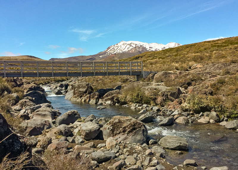
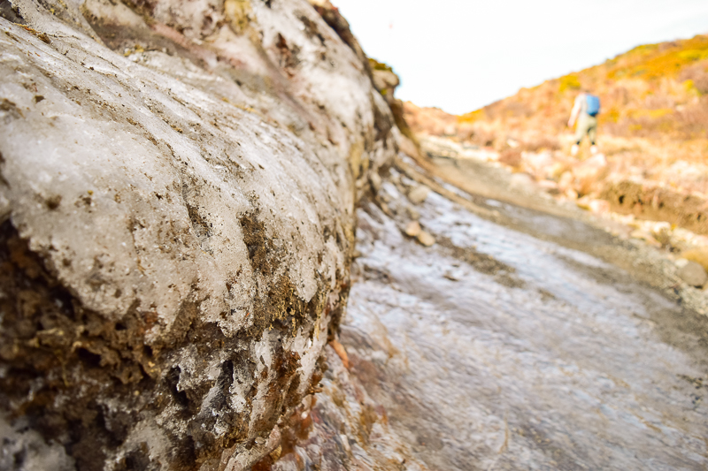
That said, many of the streams and rivers that flow from Mt Ruapehu (such as the one you will cross on this track pictured below) are snowmelt and safe to drink from (if treated first) in the absence of any volcanic activity.
Rather than relying on these sources, and to ensure you’re respecting cultural values, I recommend you bring a minimum of 2L of water per person from home.
The Track is Very Exposed
Aside from the first 10 – 15 minute section which cuts through a small bush section, there is absolutely no shade on this track.
In summer, regardless of whether the sun is out or not you’re at the constant mercy of the harmful UV rays which cause burning and skin damage.
I speak from experience. As I neared the bridge over the Taranaki Falls on my return journey on this trip I realised I’d suffered severe sunburn to my legs over the last four hours of hiking. By the time I got home I was in agony and liberally applying burn ointment and cold flannels to treat some of the worst sunburn I’ve had in years.
The sun can also cause heat exhaustion and dehydration, so make sure to take a decent hat and possibly even a good umbrella to keep the worst off. Once past the first bush section there is nowhere to take shade from the relentless onslaught of the sun’s rays.
And it’s not just the sun! The valley between Mts Ruapehu and Ngauruhoe acts as a wind tunnel, and dangerously high winds are common especially at the Tama Saddle. Don’t venture to the saddle if the wind speed is high, as you might be blown off the top.
Check the Weather, Your Clothes & Sun Protection
On a good day, the Tama Lakes Track can be a fantastic alternative to the crowded Tongariro Alpine Crossing. But on a bad day, it can be very dangerous.
Due to the alpine nature of this territory, make sure to check the weather forecast before you go. If the forecast is for low visibility, high wind speeds, low (or high) temperatures, rain or snow, it’s probably best to wait for a better day.
Make sure you have appropriate clothing. The Tama Saddle is prone to bitter bone-chilling winds, so make sure you take a good windbreaker. The conditions at the Saddle could be very different to the conditions you find on the rest of the track, so you’ll need to have good layers:
- Base Layer: Start with a light-medium weight merino layer;
- Mid Layer: Pop a fleece or merino jumper over the top;
- Outer Layer: Finish up with a good jacket (down is nice and warm) and a softshell or rain jacket to keep the wind out).
- Extras: Add gloves and a beanie in winter, or a wide-brimmed hat in summer.
Check your pack for sun protection. In summer you’ll need to apply sunscreen to any exposed skin – UV levels are very harsh because the terrain is higher and you’re that little bit closer to the ozone layer.
Depending on the size of your day pack, you may also consider attaching an umbrella to the outside to keep the sun off if it gets too strong.
How to get there.
Use the map above to get directions via your phone’s map app.
Trampers can reach the Tama Lakes track in a number of ways.
Via Tongariro Northern Circuit Great Walk
Those tramping the Tongariro Northern Circuit Great Walk will encounter the lakes on day three or four (if walking in a clockwise direction) after leaving the comfort of Waihohonu Hut.
Heading back towards Whakapapa Village, the Tama Lakes side trail branches off to the right, and it’s a short stroll to the first viewpoint at the Lower Tama Lake.
From Whakapapa Village
The most popular start/end point for day hikers is at Whakapapa Village.
Park your car either in the carpark opposite the Fire Station, or at the end of Ngauruhoe Terrace in the designated Taranaki Falls/Northern Circuit carpark (be warned that during summer, after about 8am this carpark is usually already full).
For the easiest trek to the lakes, look for the signs to Taranaki Falls via the Upper Loop. It is possible to get to the lakes via the Taranaki Falls Lower Loop, but your hike will be slightly longer, and you’ll have to climb a steep set of stairs just past the falls.
Instead, visit the Taranaki Falls via the Lower Loop on your way back to the carpark.
Track Grade & Fitness.
The track is mainly a nicely formed pathway which has been cut through the landscape and uses either gravel or geocell mats for extra traction.
It’s wide enough in most places for two people to pass side by side and there are some short boardwalked sections over sensitive landscapes.
Most streams and rivers are bridged, but there are one or two (including part of the Taranaki Stream not far from the Waihohonu Hut junction) which are not. These streams usually run dry or very low in the summer months, but in winter this may change so be prepared to get wet feet.
You Need to Be Fit To Complete This Hike
A return trip to the Upper Tama Lakes will take an average tramper approximately 5 hours, including a couple of rest-stops for lunch and a breather once you’ve climbed to the Tama Saddle/Upper Lakes viewing point.
The track traverses directly over and through ancient lava flows, meaning you’re constantly walking up, over and down these ripples in the landscape which can be very tiring over a 5 hour period (don’t forget the return journey counts too!).
Trekking poles assist in taking some of the additional pressure off tired arms and legs. Even with a day pack, the elevation gain and loss is significant enough for this to make the difference between reaching the Tama Lakes, or being forced to turn around before you arrive.
Facilities.
Much of this track forms part of the popular Tongariro Northern Circuit Great Walk, therefore the track itself is very well maintained.
In summer (October to April) you’ll likely find toilets at the Taranaki Falls track junction and Waihohonu Hut track junction. In winter, there are no toilets on the track.
Food & Water.
You’ll need plenty of food and snacks to last you the 5 hour trek full of constant hill climbing. I recommend taking a substantial lunch with you which you can tuck into when you reach the lakes. A couple of extra muesli bars and some high-energy snack foods such as scroggin or chocolate will keep your energy up for the vigorous climbs.
You’ll need a minimum of 2L of water per person in the height of summer.
Don’t rely on being able to fill up your water bottle on this track. Aside from the fact that rivers and lakes in this region are tapu (sacred) to local iwi, there are very few streams on the track and many of them are not advised to drink from due to the volcanic content.
Seasonal Variations.
The best time of year to walk this track is during the shoulder season in Spring and Autumn. At this time of year extreme summer temperatures have past, but we’re not quite into the biting cold of winter in the mountains.
The biggest weather risk is rain and strong wind, particularly at the Tama Saddle.
This track is very exposed so you’ll need to be well prepared and always carry thermal layers, and a waterproof and windproof layer to prevent the risk of hypothermia.
In winter, this track is an easier alternative to the Tongariro Alpine Crossing, which requires specialist equipment and a guide (for less-experienced trampers) due to alpine conditions. Snow and ice is still likely to be present, however, which may make the track treacherous in places.
Inexperienced trampers shouldn’t attempt the climb to the Tama Saddle in snow or icy conditions, and may benefit from the use of microspikes on the remainder of the track.
More Tracks In This Region
The tama lakes track Route.
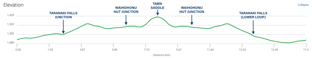
The Tama Lakes Track is a 17km / 10.5mi out-and-back (return) trip with approximately 480m / 1.574 ft of total ascent. It can roughly be divided into the following sections:
- Upper Taranaki Falls Track – 2.8km / 1.7mi – 20-30 min
- Waihohonu Hut Track – 3.7km / 2.3 mi – 1hr
- Lower Tama Lake – 0.5 km / 0.3 mi – 15-20m
- Tama Saddle Track / Upper Tama Lake – 1.3-2km / 0.8-1.2mi – 20-30min
- Tamma Saddle / Upper Tama Lake to Whakapapa Village – 9km / 5.6mi – 2.5hr
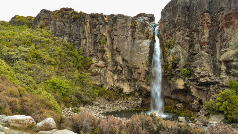
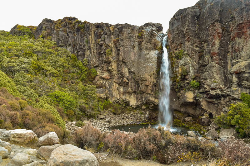
SECTION 1: Upper Taranaki Falls Track
A short walk from Whakapapa Village, the Taranaki Falls Track is a loop track which can be walked in either direction via either the Upper or Lower Loop Tracks.
Those wishing to minimise on the elevation gain are well advised to begin with the Upper Loop which brings you to a bridge over the top of the falls approximately one hour after leaving the Tama Lakes trailhead carpark.
This section of the track is easy grade and suitable for families and trampers of almost all ages and abilities. At the track junction at the top of the falls you’ll find a signpost which directs you back to Whakapapa Village on the Lower Loop track to the left, and to Waihohonu Hut (4hr 30min) and the Lower Tama Lake (2hr) to the right. A short detour down the staircase to your left will take you to the bottom of the Taranaki Falls. There’s a small picnic table here for a wee snack whilst you take the opportunity to have a good gander at the falls.
SECTION 2: Waihohonu Hut Track
Turning right at the Upper Tanaraki Falls track junction, you’re on the Tongariro Northern Circuit which is immediately obvious from the fact that you immediately begin a decent climb. This is a good test of your fitness ability (and how exposed to the elements you feel) as much of the track continues on like this. There is a distinct lack of stairs to aid in the climbing, the track instead being cut directly into the landscape and strengthened by geocell mats which are used by DOC to protect against erosion and give greater stability. These can be a significant trip hazard where track material has washed away.
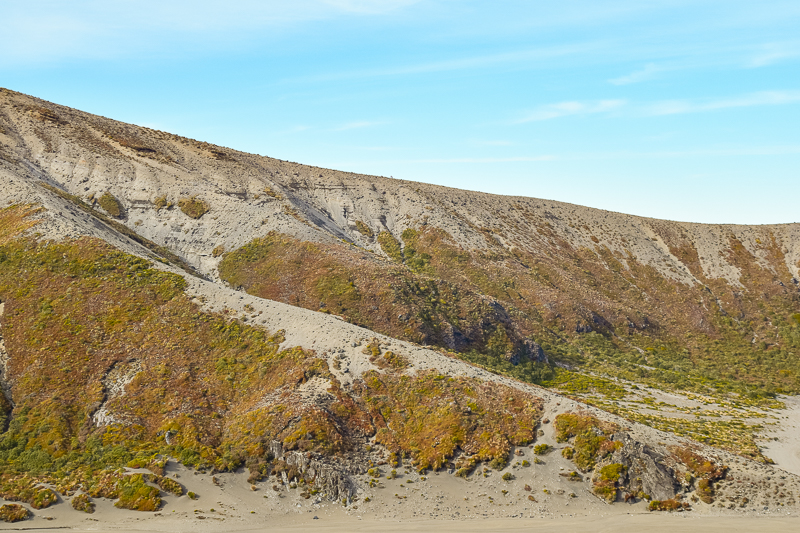
Most of the climbing and descending on this section is due to the presence of ancient lava flows, hardened remnants of past eruptions in the region which have created a bent and buckled landscape. It’s tough tramping as you climb up and over one lava tongue, only to drop into the valley below the next one. Having said that, it’s still achievable even by less fit trampers if you leave yourself plenty of time, take plenty of breaks, and remember to keep drinking your water.
Being also part of the Round the Mountain track, this section is graded an advanced tramping track meaning there are some small un-bridged river crossings to navigate (in summertime these are usually just trickles).
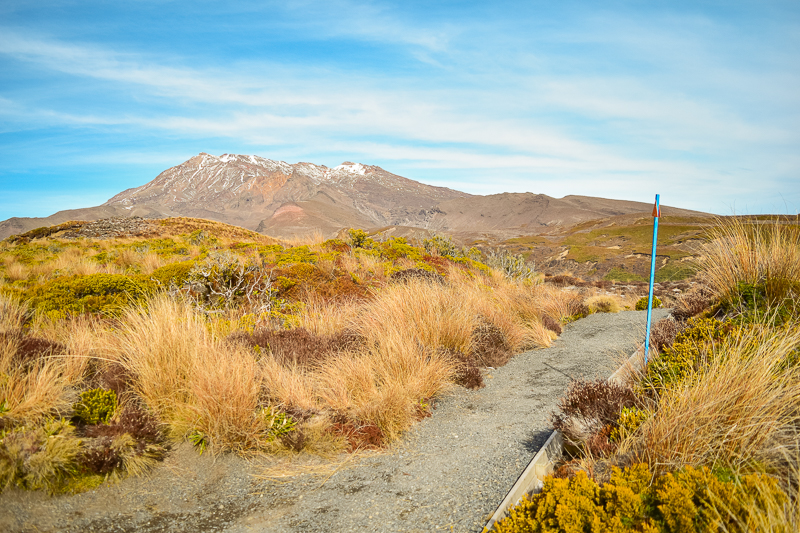
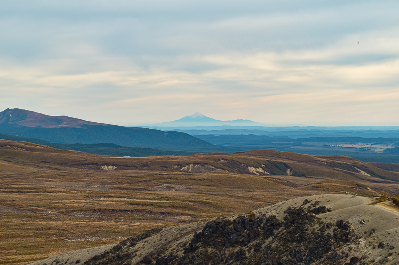
There are fantastic views of both Mts Ruapehu and Ngauruhoe all along this section of track. On a clear day you’ll be able to get some fantastic photos. Make sure to take a camera with you!
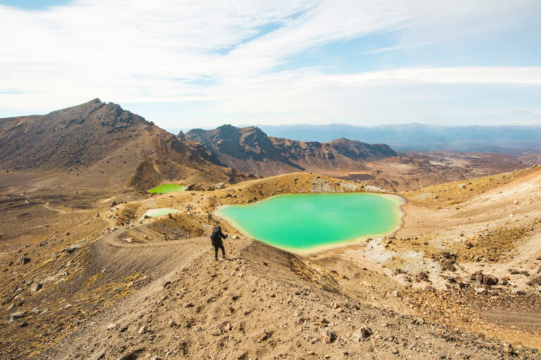
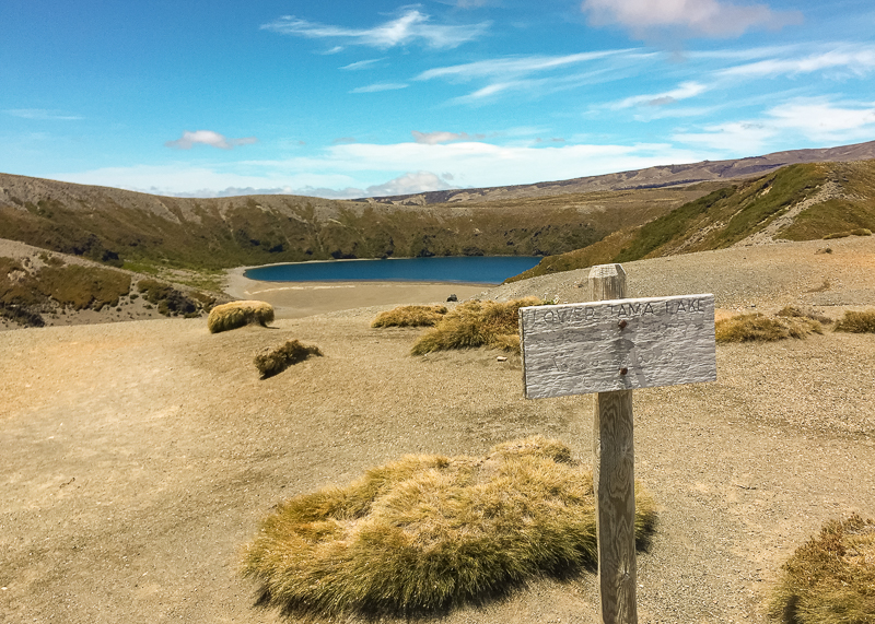
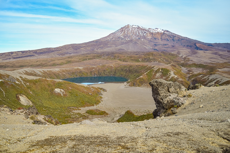
Eventually you’ll reach the junction with the Waihohonu Hut track. The hut is still approximately 2.5hrs away, but the Lower Tama Lake is just a short 10 minute stroll up the track to your left.
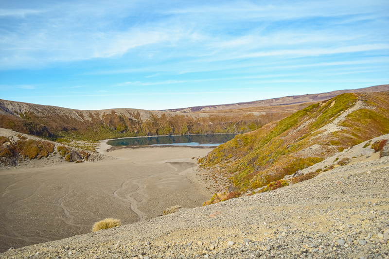
The Lower Lake sits at 1,240m / 4,068ft. remembering that the Tongariro National Park Visitor Centre is already 800m /2,624ft above sea level. There is plenty of opportunity to venture off track here and find a nice place to have something to eat. You’ll already have been walking for 2 hours by this point, so it’s definitely time for a well-earned rest.
Access to the shores of the lake requires scrambling down some steep and precarious terrain, so it is reserved for only the most experienced trampers (and probably better from an alternative route). If you decide to make the trip, however, remember that the lake is tapū (sacred/protected) so refrain from touching the lake or drinking its water (the water in the lake is likely not safe to drink regardless).
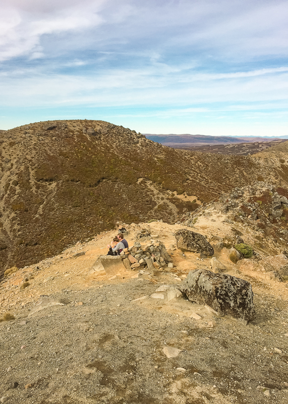
It’s not uncommon to see more experienced trampers venturing up the ridgeline immediately opposite the Lower Tama Lake viewpoint on their way to the Tama Saddle via an un-marked but relatively straightforward off-track route. If you look very closely you’ll see two tiny trampers on the high ridgeline in the middle of this photo doing exactly that.
SECTION 3: Tama Saddle
After stopping for a short snack or lunch break at the Lower Tama Lake it’s time to push on to the Tama Saddle and the Upper Lake viewpoint (if it’s safe to do so). The track becomes a little more advanced in the next section, involving a steep (in places) scramble up a loose scree slope and onto an exposed ridgeline. Although the ridge is fairly wide at most points, it narrows as it gets closer to the Tama Saddle summit and there are steep drop-offs to either side.
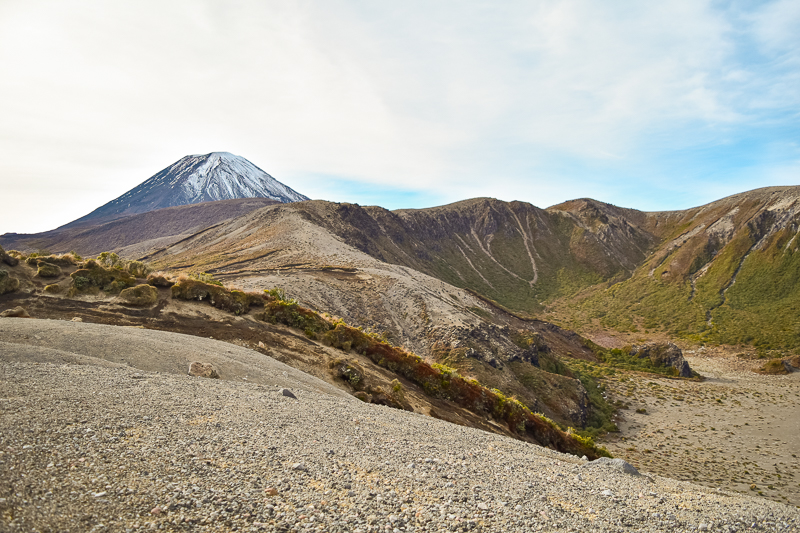
You can see the dip of the Tama Saddle in the middle of this photo just to the right of Mt Ngauruhoe. The track to the Saddle follows the rim of the small valley beneath the saddle which snakes down and away from it to the left at a 45 degree angle.
Although daunting from the bottom, the climb up the scree slope is simple enough if taken carefully. The gradient of the slope is far less than that experienced on the descent from Red Crater on the Tongariro Alpine Crossing. The scree is quite deep in most places meaning it’s easy to dig in your feet for a better foothold. A blue poled route and some cairns show the way, and it should take average trampers 30-35 minutes to reach the Saddle from the Lower Lake viewpoint.
Regardless of the composition of the trail on this section, the biggest danger here is the prevailing westerly wind which roars up the valley and over the Tama Saddle. Up until this point, I had had nothing but calm weather and the barest breath of wind. however, as I started climbing I noticed the wind picking up. Once on the Saddle, I sometimes had to brace myself against the stronger gusts and be careful to stay away from the edge of the ridge.
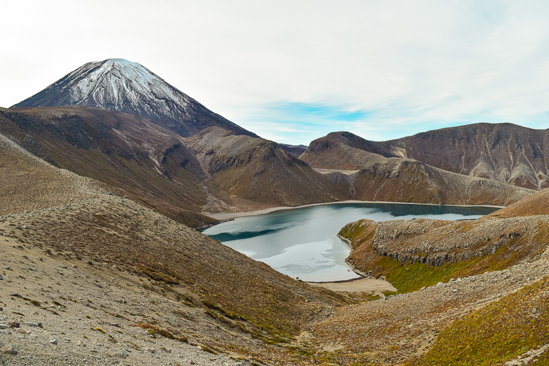
A short traverse along the top of the saddle towards its farthest extent provides the best view of the Upper Lake (1,440m / 4,724ft). There is one large boulder behind which it might be possible to shelter from the wind, as long as someone else hasn’t gotten there first! There are places to sit and take in the view, and you’ll certainly want to do this.
Interestingly, once up and over the far crest of the saddle, the wind seemed to die down, and there was no other sound. It’s a staggeringly serene and tranquil place. There were a few other trampers at the viewpoint with me, but I honestly can’t remember hearing them, much less being disturbed by their presence. It was as if we’d all at once lost our voices and submitted to the landscape.
Final thoughts.
If you’re looking for a hike which showcases the best of New Zealand’s volcanic and geological history, you can’t go wrong with the Tama Lakes Track. The lakes themselves are ancient explosion craters, probably formed around 10,000 years ago, and you can view some of the most ancient lava flows of Mts Ruapehu and Ngauruhoe from the Tama Saddle.
I love to explore landscapes like this, which is probably why the Tongariro National Park is one of my favourite places to hike. I get an incomprehensible feeling of the weight of time when visiting them. The landscapes around us have been sculpted for millennia. We might gaze out upon them and wonder at their beauty, but how many of us connect the dots?
As humans, we’re often guilty of thinking we have all the time in the world to live our lives, achieve the things we want to achieve, and give as much back to the world as we take from it. Unfortunately, the reality is that we simply don’t. Each of us can only make a small pinprick in the tapestry of time, which is why it’s important to make sure that we’re kind to others, genuine to ourselves, and that we smile more than we should.
If you found this Tama Lakes Track Guide helpful, please take a moment to help me spread the word to other trampers and hikers by sharing it on Pinterest (or on your social media).